International Parks
  • Explore
  • Map
  • Ratings
  • Review
  • Wiki
  • Suggest a Park
  • About
Log In
  1. Home
  2. South Korea Parks
  3. Seoraksan

Quick Actions

Park SummaryView on MapSouth Korea WikiWiki HomeWrite ReviewReport an Issue

Nearby Parks

Amisan15 kmNaksan19 kmDaeamsan-Daewoosan27 kmYongneup of Daeamsan29 kmOdaesan38 km

Platform Stats

23,798Total Parks
217Countries & Territories
Support Us
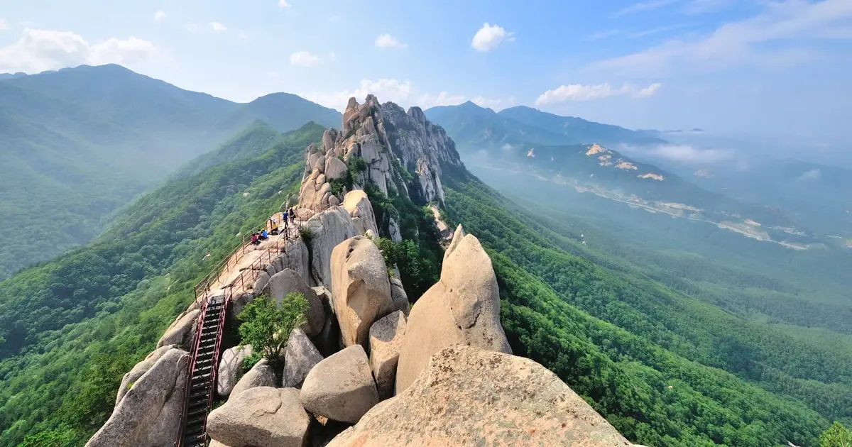
Seoraksan in Gangwon, South Korea

Seoraksan

South Korea, Gangwon

  1. Home
  2. South Korea Parks
  3. Seoraksan

Seoraksan

LocationSouth Korea, Gangwon
RegionGangwon
TypeNational Park
Coordinates38.125°, 128.416° (show on the map)
Established1970
Area398 km²
Nearest CitySokcho (10 km)
See all parks in South Korea →
Contents
  1. Park Overview
    1. About Seoraksan
    2. Wildlife Ecosystems
    3. Flora Ecosystems
    4. Geology
    5. Climate and Weather
    6. Human History
    7. Park History
    8. Major Trails and Attractions
    9. Visitor Facilities and Travel
    10. Conservation and Sustainability
  2. Visitor Information
    1. Visitor Ratings
    2. Photos
  3. Sources

About Seoraksan

Seoraksan National Park lies in the Taebaek Mountains of Gangwon Province, across Sokcho, Yangyang, Inje and Goseong[1]. It covers 398.22 km²[2]. The mountain was made Natural Monument No. 171 in 1965, a national park on 24 March 1970 and a UNESCO Biosphere Reserve in 1982[1]. The highest peak, Daecheongbong, rises to 1,708 m, the third-highest in South Korea after Hallasan and Jirisan[1]. The park divides into Inner Seorak (Inje side), Outer Seorak (Sokcho side) and Southern Seorak (Yangyang side)[1].

Wildlife Ecosystems

About 1,562 animal species are recorded[2]. Protected species include the Asiatic black bear, Siberian musk deer, Korean goral, otter, Siberian flying squirrel and Manchurian trout[1]. The Korean goral is described as the symbol animal of the mountain[1]. Tristram's woodpecker is among the endangered birds[2].

Flora Ecosystems

About 1,013 plant species are known, 822 of them vascular plants[2], including 65 endemic and 56 rare species[1]. Forests are dominated by Mongolian oak, Japanese maple and Korean fir, mixed with pine, Korean pine and Korean spruce[1]. Siberian pine is abundant on the southern slope and oaks dominate the northern slopes[2].

Geology

The outer areas are Precambrian gneiss, while the central area is Jurassic and Cretaceous granite, which forms the rugged peaks including Gongnyong Ridge and Ulsanbawi[1]. A small Cretaceous sedimentary layer, the Baekdam Group, occurs in the Baekdam Valley, and several faults cross the mountain, among them the Hangyeryeong, Gaya-dong and Misiryeong faults[1].

Climate and Weather

The average annual temperature is below 10°C, and annual rainfall is about 1,000 mm in Inner Seorak and about 1,300 mm in Outer Seorak[1]. Inner Seorak has a continental climate and Outer Seorak a maritime one[1]. Snow covers the mountain for five to six months a year, which gives "Seorak" (snow peak) its name[1]. Rain falls mostly in heavy summer downpours[2].

Human History

After liberation the mountain lay in North Korean territory until the Korean War, then came under South Korean control[1]. The Buddhist temples Sinheungsa and Baekdamsa are listed cultural landmarks[2]. The 17th World Scout Jamboree was held on Mount Sorak from 9 to 16 August 1991[2].

Park History

Seoraksan was protected as a nature reserve in 1965, designated a national park on 24 March 1970 and recognised by UNESCO as a Biosphere Reserve in August 1982[1]. The Korea National Park Service manages it[2].

Major Trails and Attractions

Outer Seorak's best-known sights are Ulsanbawi, Heundeulbawi, Biryeong Waterfall and Yukdam Waterfall[2]. Main routes include Cheonbuldong Valley from Seorak-dong toward Daecheongbong, Gongnyong Ridge (about 5.1 km), the Baekdam Valley route from Yongdae-ri via Baekdamsa to Sogcheongbong and Daecheongbong, and Osaek and Hangyeryeong access[1]. A cable car near Seorak-dong climbs to Gwongeumseong[1].

Visitor Facilities and Travel

Visitor centres and ticket booths stand at the park entrances[1]. Mountain shelters include Yangpok, Huiungak, Seorak (Jungcheong), Sogcheong and Suryeomdong[1]. A shuttle bus runs up the Baekdam Valley to a point about 4 km from the ticket booth, and Sokcho is the nearest town[1].

Conservation and Sustainability

The whole mountain is designated for protection because of its geology, flora, fauna, scenery and cultural heritage[1]. Some areas, such as parts of the Northern Ridge, are closed under a natural rest-year system that prohibits entry[1].

Visitor Ratings

Not yet rated. Been here? Your review gives this park its first scores.

Write a review

Photos

1 photo
Seoraksan in Gangwon, South Korea

Sources

  1. ko.wikipedia.org/wiki/설악산국립공원 (opens in a new tab)
  2. en.wikipedia.org/wiki/Seoraksan_National_Park (opens in a new tab)

International Parks

Helping nature enthusiasts discover and explore the world's most remarkable protected areas.

© 2026 International Parks. All rights reserved.

Navigation

  • Home
  • Explore Parks
  • Interactive Park Map
  • Park Ratings & Rankings
  • Park Wiki
  • Parks by Country

Resources

  • About Us
  • US National Park Seasons
  • Privacy & Terms
  • Copyright & Takedown

Account

  • My Profile
  • Suggest a Park
  • Write a Review
  • Log In
  • Sign Up

Connect

Support This Project

Contact Us

internationalparksbusiness@gmail.com

Explore by Country

  • United States
  • Canada
  • Australia
  • United Kingdom
  • Japan
  • Brazil
  • India
  • France
  • Germany
  • Italy
  • Spain
  • Thailand
  • All countries